- Success Stories
- Environmental Resource Assessment & Management
Expanding Our Offshore Wind Team

We’ve recently added several staff to bolster the offshore wind team at NOAA’s National Centers for Coastal Ocean Science. With this full team of 13, our employee owners are able to provide more focused support in their areas of expertise, including mapping and spatial modeling, data collection, communications, project management, and partner engagement. Through this work, the team develops regional ecosystem-wide spatial models to inform siting of ocean use sectors, environmental review, and permitting, which provides guidance to the Bureau of Ocean Energy Management (BOEM) on suitable locations for offshore wind siting.
Sustainable coastal planning and development increases resiliency, creates jobs, reduces reliance on unsustainable imports, supports renewable energy, and grows the domestic Blue Economy. Check out the NCCOS Coastal & Marine Planning and Offshore Wind Energy spatial planning webpages to learn more.
This team is now providing spatial planning support in all U.S. ocean regions and was recently instrumental in BOEM designating two Wind Energy Areas in the Gulf of Mexico. As offshore wind continues to expand throughout U.S. waters, this team will continue to collaborate with BOEM to support the identification of suitable locations for renewable energy. Future work is slated for the U.S. Central Atlantic, Gulf of Maine, Oregon, and more to come!
See More CSS Insights

Developing Data and Tools to Support Offshore Wind
We have a team of staff who support offshore wind and other ocean planning efforts through two contracts with the National Oceanic and Atmospheric Administration. This team provides data development and management, web content management, and communication for the MarineCadastre.gov suite of products. Over several years, the team has produced, processed, and maintained nearly 300…
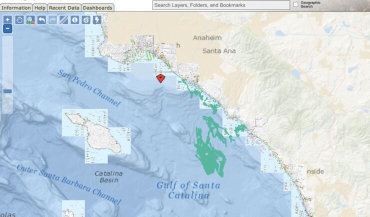
Ongoing Support for the Huntington Beach Oil Spill
Oil spills are disastrous and the clean-up is ongoing. Following the Huntington Beach, California oil spill in October 2021, our staff supported the National Oceanic and Atmospheric Administration’s Office of Response and Restoration with communications, data collection, and damage assessments. As various agencies collected data, our staff assisted the client in developing this map to…
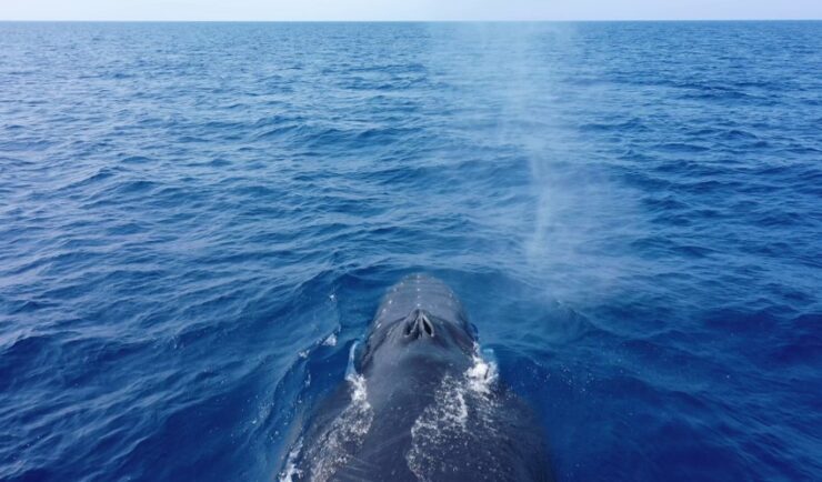
Training Marine Mammal Programs to Use Drones to Collect Dolphin and Whale Respiratory Health Data
CSS employee owner and Marine Mammal Drone Specialist supports NOAA’s National Centers for Coastal Ocean Science (NCCOS) Marine Mammal Health Assessment team with collecting respiratory health data from marine mammals in local waterways. Using specialized drones equipped with petri dishes provides a non-invasive method to collect exhaled breath (i.e. blow) samples from dolphins and whales.…